National Register Historic District Nominations
Historic districts are cohesive collections of buildings associated by geography, historical development, and/or architecture.
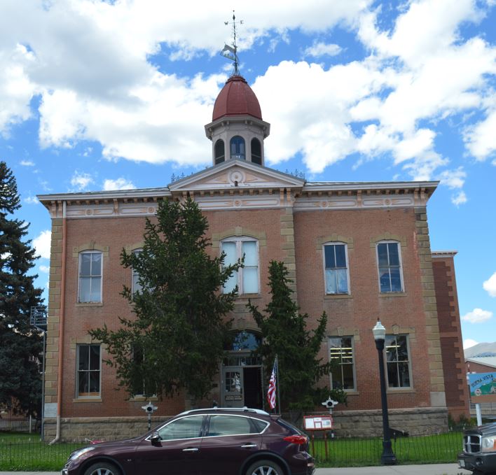
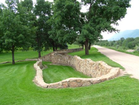
Chaffee County Courthouse Complex, Buena Vista, Colorado (2022-23). Front Range prepared documentation to amend the existing 1979 National Register nomination for the former Chaffee County Courthouse in Buena Vista, Colorado. The building group includes the 1881 Courthouse and Jail buildings (designed by British architect George E. King), a 1936 rear gymnasium addition constructed by the New Deal Public Works Administration (PWA), and a circa 1960 Chaffee County shop building. The amended nomination expanded the boundary to include the shop, corrected the legal description, provided fuller architectural descriptions, expanded the historical background, and discussed and justified additional areas of significance.
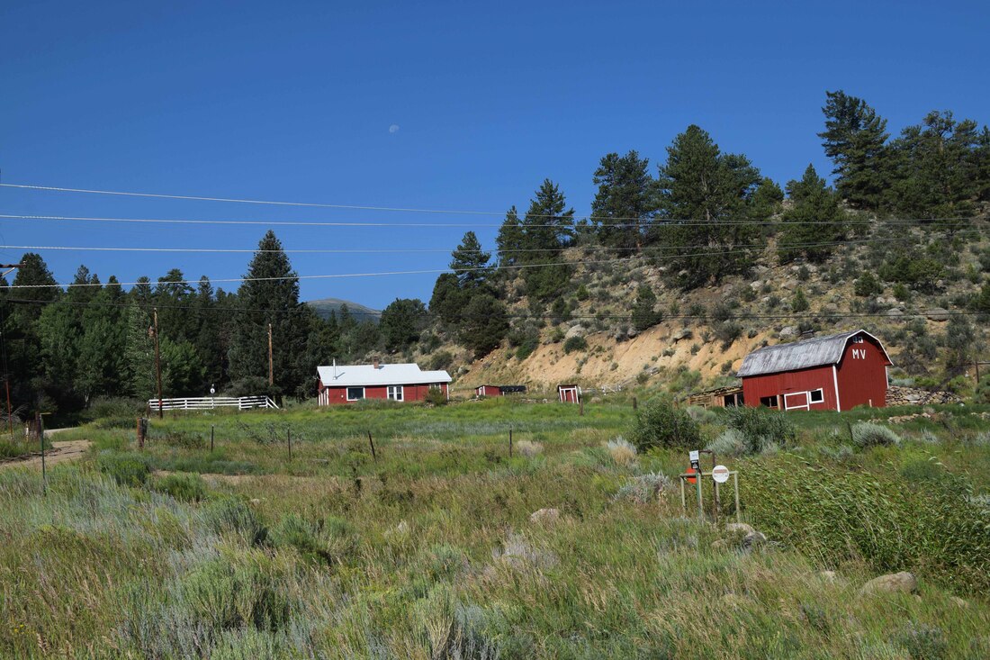
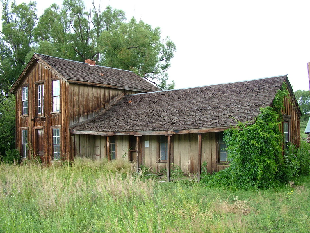
McFadden Brothers Ranch East Headquarters, Buena Vista, Colorado vicinity (2021-22). Located on the historic McFadden Brothers ranch about nine miles north of Buena Vista, the east headquarters and associated agricultural fields were nominated as a National Register historic district. The small headquarters complex includes a house, shed, root cellar, privy, and barn and was evaluated as significant for its Architecture and association with Agriculture.
Coronado Lodge, Pueblo, Colorado (2020). Historic Pueblo, Inc., engaged Front Range to prepare a National Register district nomination for the Coronado Lodge (now the Coronado Motel). The Pueblo Revival-style motel was built ca. 1940-41 to ca. 1946-48. Four of the buildings feature adobe wall construction using bricks produced by Pueblo adobero Jose B. Garcia. The buildings feature projecting vigas (thought to have been harvested from trees in Beulah) and peeled log porch posts with corbels (zapatas). Beginning ca. 1946, the motel welcomed African American guests under second owners Arthur and Hattie Copley, who listed the facility in The Green Book, a national publication identifying safe havens for African-American travelers during the era of segregation. The Pueblo Chieftain ran a recent article in which residents were asked to share their memories of the facility: Article Link
Our Lady of Guadalupe Church in Conejos, Colorado, Colorado (2019). The 1927/1948 Our Lady of Guadalupe Church in Conejos, Colorado, the mother church of the oldest Catholic parish in Colorado, is significant in the area of Hispano/Latino, erected by and serving a Hispano congregation, and in the area of Social History, providing a venue for community celebrations and other events. Our Lady of Guadalupe Church serves a heavily Hispano parish, and its parishioners participate in administering the church and contributing to its construction and ornamentation. Hispano individuals, families, and church-related groups sponsored the church’s striking aluminum domes and its extensive installation of figural stained-glass windows. The congregation honored their poblador ancestors by persuading the Denver Diocese to rebuild the church in its original location after a 1926 fire. The church has been a focal point for community events since its initial founding in the 1850s. The present church has been the site of funerals, weddings, and feast days. The area south of the church has held community bonfires, an annual summer festival, and is planned as a site of a prayer labyrinth honoring the area’s pobladores (settlers).
Our Lady of Guadalupe Church is significant in the area of Architecture as an example of the Spanish Colonial Revival style, as reflected in the twin square towers with aluminum hipped domes, use of contrasting gray concrete bricks and orange clay bricks, and round-arch windows. The church is notable as a work of Lakewood, Colorado, architect John K. Monroe, Sr., who designed the 1948 expansion of the church with its signature twin towers. Monroe executed scores of commissions for the Denver and Pueblo Catholic dioceses, particularly in the post-World War II period. The church is also significant in the area of Art for its extensive installation of stained-glass windows, hand-crafted altar, statuary, and other works of art. Stained glass scholar Virginia C. Raguin commented on church’s windows: “The exciting issue about your windows is the subject matter closely tied to Hispanic piety in the Southwest of this time. The Santo Niño and Jesús Nazareno are striking. … [The survival of] an intact program of glass from this time is always important.” The figural windows, very likely fabricated by Frank Watkins of Denver, portray saints and religious images of particular importance to Hispano devotion. The elaborate altar was fabricated in 1934 by assistant priest Nicholas Femenia, area carpenter Benjamin Chavez, and local artist Epifanio Trujillo, who earlier provided decoration for St. Cajetan’s Church in Denver.
Our Lady of Guadalupe Church is significant in the area of Architecture as an example of the Spanish Colonial Revival style, as reflected in the twin square towers with aluminum hipped domes, use of contrasting gray concrete bricks and orange clay bricks, and round-arch windows. The church is notable as a work of Lakewood, Colorado, architect John K. Monroe, Sr., who designed the 1948 expansion of the church with its signature twin towers. Monroe executed scores of commissions for the Denver and Pueblo Catholic dioceses, particularly in the post-World War II period. The church is also significant in the area of Art for its extensive installation of stained-glass windows, hand-crafted altar, statuary, and other works of art. Stained glass scholar Virginia C. Raguin commented on church’s windows: “The exciting issue about your windows is the subject matter closely tied to Hispanic piety in the Southwest of this time. The Santo Niño and Jesús Nazareno are striking. … [The survival of] an intact program of glass from this time is always important.” The figural windows, very likely fabricated by Frank Watkins of Denver, portray saints and religious images of particular importance to Hispano devotion. The elaborate altar was fabricated in 1934 by assistant priest Nicholas Femenia, area carpenter Benjamin Chavez, and local artist Epifanio Trujillo, who earlier provided decoration for St. Cajetan’s Church in Denver.
St. Joseph’s Church and Cemetery, Capulin, Colorado (2019). St. Joseph’s Church and Cemetery is significant in the area of Latino/Hispano history for its association with its overwhelmingly Hispano parish. Beginning in the late 1840s-early 1850s, Hispanos from northern New Mexico began the Euro-American settlement of the San Luis Valley of present-day Colorado. These early pobladores (settlers) brought with them traditions developed over two centuries of Spanish and Mexican control of the Southwest, producing a “cultural impress” on the new territory. The Capulin area was settled in the 1860s and an initial Catholic church built in 1878. Members of the church led the movement to build the present church in 1912-13 and contributed money, time, and labor toward its construction. The church is further significant in the area of Social History as a focus of community events for the people of Capulin and the surrounding area of northern Conejos County. The religious life of the church played an important role in the broader community, with St. Joseph’s serving as the site of weddings, funerals, christenings, seasonal feasts, and other events. The church complex also housed Benedictine sisters who staffed the local public school for nearly thirty years.
St. Joseph’s Church is significant for its architecture, as a well preserved example of an early-twentieth century Gothic Revival-style Catholic church. The church displays pointed Gothic-arch windows and entrances, rock-faced sandstone walls, stone buttresses, and a square tower with shingled belfry and multiple crosses. Although an architect could not be identified, a church history documents individuals involved in the original stone work: stonecutters Senno Maestas of Capulin and Eugene Maestas of Taos, New Mexico, and stonemason Justo Duran of Monte Vista, Colorado. The church is significant in the area of Art for its extensive display of highly artistic interior ornament, including historic stained-glass windows in the original church and chapel. Seventeen Gothic-arch stained-glass windows illuminate the chancel, choir loft, and the north and south walls of the nave, all identifying the name of the Hispano individual, family, or organization donating funds for the window’s installation. The chapel features nine similar stained-glass windows in its east and west walls. The chancel contains an elaborate Gothic altar, imported from Italy in 1924. Other paintings, statues, and artistic works reflecting religious themes ornament the interior.
St. Joseph’s Church is significant for its architecture, as a well preserved example of an early-twentieth century Gothic Revival-style Catholic church. The church displays pointed Gothic-arch windows and entrances, rock-faced sandstone walls, stone buttresses, and a square tower with shingled belfry and multiple crosses. Although an architect could not be identified, a church history documents individuals involved in the original stone work: stonecutters Senno Maestas of Capulin and Eugene Maestas of Taos, New Mexico, and stonemason Justo Duran of Monte Vista, Colorado. The church is significant in the area of Art for its extensive display of highly artistic interior ornament, including historic stained-glass windows in the original church and chapel. Seventeen Gothic-arch stained-glass windows illuminate the chancel, choir loft, and the north and south walls of the nave, all identifying the name of the Hispano individual, family, or organization donating funds for the window’s installation. The chapel features nine similar stained-glass windows in its east and west walls. The chancel contains an elaborate Gothic altar, imported from Italy in 1924. Other paintings, statues, and artistic works reflecting religious themes ornament the interior.
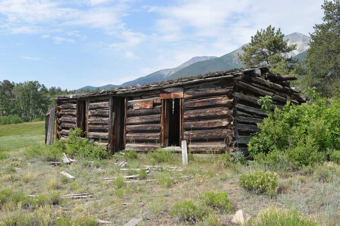
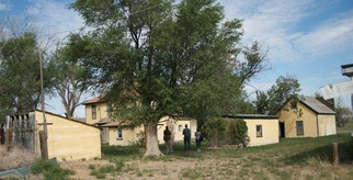
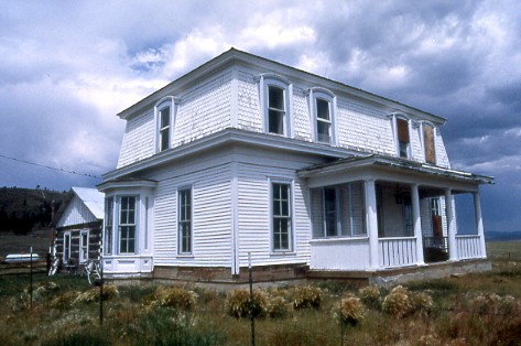
García/Espinosa/Garland Ranch Headquarters, Antonito vicinity, Colorado (2019). The García/Espinosa/Garland Ranch is significant in the area of Hispano/Latino history as a ranch settled and developed by Hispanos from ca. 1885 to 1937 and with resources displaying common characteristics of Hispano construction, such as adobe. José Victor García acquired part of the land comprising this ranch in 1882 and transferred it to his son Celestino in 1887. The eastern part of the ranch was settled by another son, Lafayette García. Both José Victor and Celestino were active in Colorado politics and served in the state legislature. Celestino lived on the ranch from ca. 1885 to his death in 1925. His family then sold it to Francisco A. Espinosa, who was active in politics and in the Sociedad Protección Mutua de Trabjadores Unidos (SPMDTU), a Hispano fraternal and civil rights organization. The property also possesses significance in the area of Agriculture, for its association with agriculture in Conejos County, as a ranch/farm raising sheep, cattle, hay, and field crops, initially under the Garcías and Espinosas and later under the Garlands.
The ranch is further significant for its architecture, for its representation of a variety of building types found on historic ranches in southern Colorado, including a dwelling, granaries, potato shed, sheep sheds, and a corral, and for featuring examples of Hispano adobe and vernacular frame construction. Two examples of Hispano adobe construction are present. The dwelling is an example of Hispano/Linear Plan design, as reflected in its side-by-side room plan, U-shaped floorplan, corner fireplaces, and multiple exterior entrances. Photographer and landscape historian Robert Adams noted “the arrangement of rooms in a line related to the patriarchal family structure. When a son married, he brought his wife back to his father’s home (partly because in time he would inherit some or all of the father’s land, and partly because, until his death, the father remained an absolute center of authority). After rooms were added to accommodate the families of several sons, a house might grow to considerable length.” Celestino and Sedelia García likely expanded the house in the early 1900s as their family grew to include seven children. The above ground adobe potato cellar reflects a building type once widely used in the San Luis Valley, but increasingly threatened and not yet represented in the National Register in Colorado.
The ranch is also significant in the area of Historic Nonaboriginal Archaeology, for its potential to yield information important to history due to buried and surface archaeological remains. The site contains archaeological ruins and artifacts that have yielded and are likely to yield important information about the use of the ranch over time. Marilyn A. Martorano contributed the archaeological portions of the nomination.
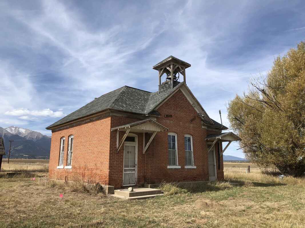
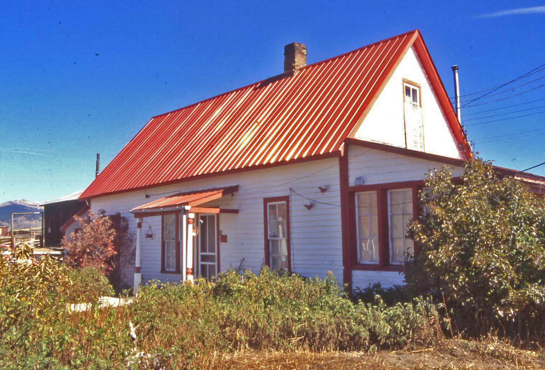
Gas Creek School, Nathrop vicinity, Colorado (2018). The 1909 Gas Creek School (an iconic landmark on the west side of US 285 south of Nathrop) is historically significant in the area of Education, as it was the only school in Chaffee County School District No. 20 from 1909 to 1958. Drawing its students from the widely scattered farms and ranches of the area, the school is further significant in the area of Social History for the role it played as a place for community activities, such as dances, meetings, celebrations, and dinners for the surrounding rural area. The school is also significant for its architecture as an example of an early-twentieth century one-room rural school. The school meets the registration requirements of the Rural School Buildings in Colorado Multiple Property Documentation Form, as an example of the Schoolhouse property type. The Gas Creek School is an exceptionally well-preserved example of a one-room rural schoolhouse. The building displays many of the attributes of rural schools identified in the MPDF: one-room, one-story, rectangular plan, symmetrical façade, and hipped roof with belfry. The school is also a relatively rare example of a brick rural school building. The MPDF reported that only about 25 percent of such schools featured brick. The significance of the historic district is enhanced by the presence of support buildings and objects necessary for the functioning of the school, including privies, a shed, and playground equipment. The MPDF noted that the survival rate for such outbuildings is “quite low.”
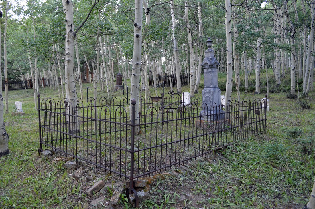
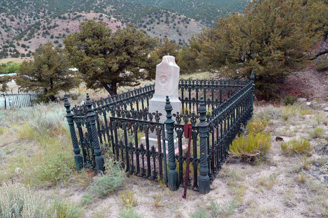
Como Cemetery, Como, Colorado (2018). The 1887 Como Cemetery historic district is historically significant in the areas of Exploration/Settlement, Industry, and Social History. The still active burial ground meets the registration requirements for listing under the Park County, Colorado, Historic Cemeteries Multiple Property Documentation Form (MPDF) under the property type “Town Cemetery.” The Town of Como established the burial ground in 1887 and operated it until the town disincorporated in the 1950s. The cemetery provided funerary services for residents of Como, surrounding small settlements, and the broader rural ranching and mining area. Victims of the January 1893 industrial accident at the King Coal Mine southeast of Como were buried in the cemetery. The accident claimed the lives of twenty-five mostly Italian miners, and Como Cemetery served as the site for the mass funeral and burial of seventeen of the victims. The disaster drew widespread newspaper coverage describing the accident and the solemn interment ceremonies taking place at Como Cemetery.
Como Cemetery, with nearly five hundred graves, is Park County’s second largest burial ground. Development of the northern part of the site followed a plat plan specifying blocks and grave plots. The cemetery features an internal road system and is the only county cemetery with a standing historic maintenance building. The burial ground is also significant in the area of Art for the craftsmanship of its monumentation, which includes a wide range of monument styles and materials, as well as thirty grave enclosures. Como Cemetery, now managed by the County Cemetery Board, continues to accept burials and welcomes visits to view the graves of loved ones or to enjoy its contemplative setting.
Como Cemetery, with nearly five hundred graves, is Park County’s second largest burial ground. Development of the northern part of the site followed a plat plan specifying blocks and grave plots. The cemetery features an internal road system and is the only county cemetery with a standing historic maintenance building. The burial ground is also significant in the area of Art for the craftsmanship of its monumentation, which includes a wide range of monument styles and materials, as well as thirty grave enclosures. Como Cemetery, now managed by the County Cemetery Board, continues to accept burials and welcomes visits to view the graves of loved ones or to enjoy its contemplative setting.
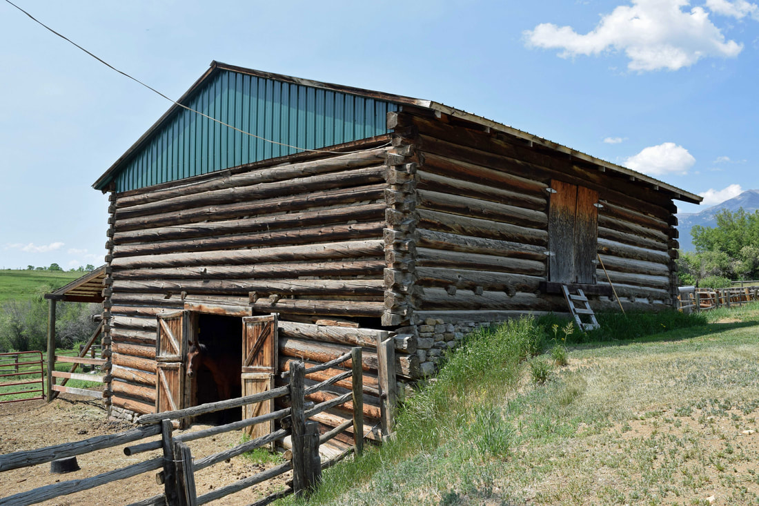
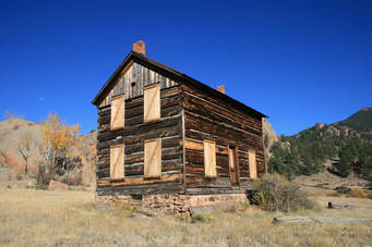
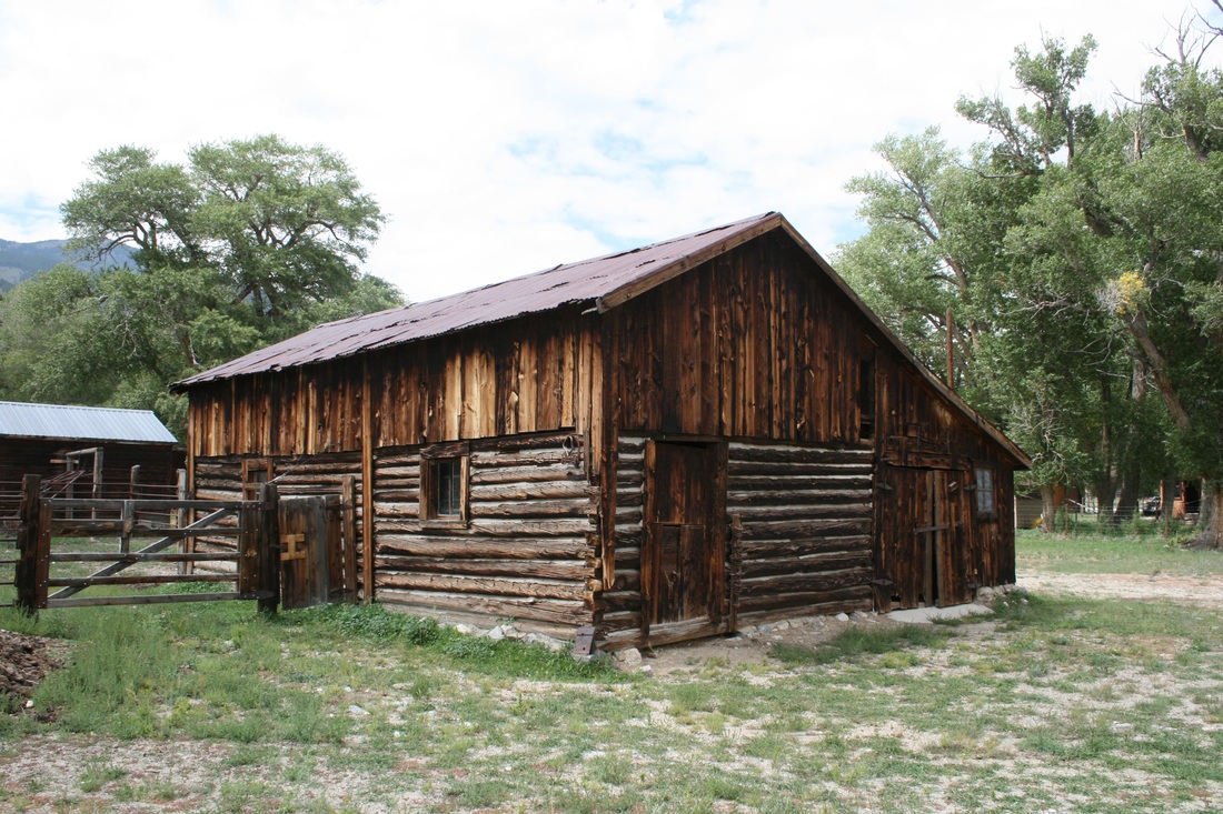
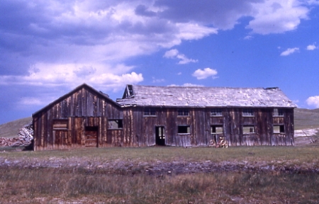
Nachtrieb/Kelly Ranch, Buena Vista vicinity, Colorado (2017). The Nachtrieb/Kelly Ranch is significant in the area of Agriculture for its association with the history of ranching in Chaffee County, serving as a cattle and hay ranch from the 1870s to the present. The original ranchland was acquired by pioneer miller, sawmill operator, townbuilder, and rancher Charles Nachtrieb in 1876. Following his murder in 1881, his widow, Margaret, and their children continued operating the cattle and hay ranch and owned the property until 1936. Following two short-term owners, the ranch has been owned and operated by the Kelly family since 1951, first by William Troy Kelly, Sr. and his wife Elizabeth, then by their son Bryce and his wife Suzanne, and currently with the participation of their son, David. The ranch is one of a dwindling number in the area that retains its water rights and still has most of its historic lands and buildings. The Nachtrieb/Kelly Ranch is also significant for its Architecture as a good representative of a late nineteenth/early twentieth-century Chaffee County cattle and hay ranch. The headquarters contains examples of building types essential to meet the needs of a self-sufficient ranch, including a log bank barn, dwellings, irrigation ditches, log granary, corral, garage, ice house, machine shop, and outhouse. The barn and granary are good examples of Pioneer Log construction, featuring hewn and round logs and full dovetail and V-notches. Nachtrieb/Kelly Ranch is further significant for non-aboriginal historic archaeology for its potential to yield information important to history due to buried and surface archaeological remains. The artifacts and archaeological deposits associated with the site have the potential to yield important data on a variety of topics including settlement patterns, socio-economic conditions, subsistence/diet, and especially ranching practices over time. Marilyn A. Martorano contributed the archaeological portions of the nomination.
Smith/Friskey Ranch, Buena Vista vicinity, Colorado (2017). The Smith/Friskey Ranch is significant in the area of Agriculture for its association with the history of agriculture in Chaffee County, beginning as a homestead and serving as a cattle and hay ranch from ca. 1888 through 1964. Andrew Smith settled here ca. 1888 and constructed the earliest building, obtaining a land patent in 1891 and remaining at the site with his family until 1900. In that year Smith sold the ranch to Gustave “Gus” Friskey. He and his brother, Ernest, undertook cattle and hay ranching here and expanded the ranch through patenting additional public lands and purchases from private parties. The brothers raised cattle, hay, and lettuce on their holdings, and staged a fall roundup to ship cattle from Buena Vista. The buildings and layout of the property are illustrative of the architecture and design of a late nineteenth- and early twentieth-century cattle and hay ranch. The two dwellings are good examples of Pioneer Log construction from that period, displaying hewn and round logs, daubing, V-notching, and gable roofs. The ranch’s resources illustrate the functional layout of a high-altitude ranch through construction of discrete areas for dwellings and a corral, barn, and sheds for animal care and transport. Root cellars and other outbuildings took advantage of the slope of the land west of the meadow in their construction. The Smith/Friskey Ranch is also significant under Criterion D for non-aboriginal historic archaeology for its potential to yield information important to history due to buried and surface archaeological remains. The artifacts associated with the cabins and other site buildings, structures, and features can and have yielded data on a variety of topics including settlement patterns, socio-economic conditions, cultural traditions, subsistence/diet, and ranching practices. Marilyn A. Martorano contributed the archaeological portions of the nomination.
Cleora Cemetery, Salida vicinity, Colorado (2017). Cleora Cemetery, the ca. 1880 pioneer burial ground in the southern Arkansas Valley of Chaffee County, is associated with the long-vacated railroad-initiated 1878 town of the same name and also served nearby communities such as Salida until they secured cemeteries. The boot hill-type burial ground features randomly sited graves displaying a variety of historic monuments and markers placed during the period of significance, ca. 1880 to 1948; only three memorial markers dedicated to pioneer families are not historic. The cemetery constitutes one contributing site. Grave markers, grave enclosures, and other components are features of the site and are not included separately in the count of resources. The cemetery displays a natural landscape unaltered by construction of buildings or structures or formal landscape architectural design. Its setting conveys its distinction as a place set apart from the activities of everyday life.
Tarryall Rural Historic District, Park County, Colorado (2017). In November 2017 the National Park Service announced the listing in the National Register of the nearly 28,000-acre Tarryall Rural Historic District in Park County in central Colorado. The recognition culminated work that started with a 1996 survey of the road. The high altitude scenic rural district embraces land along Tarryall Creek and Tarryall Road (County Road 77) bounded by the Tarryall Mountains to the north and the Puma Hills to the south. The district extends from south of Jefferson approximately 39 miles to U.S. Highway 24 northwest of Lake George. The nominated area is part of the drainage of meandering Tarryall, Michigan, and Jefferson creeks and a stretch of the South Platte River. In 1862 wagon road was constructed through the area extending from Colorado City on Fountain Creek in the Pikes Peak region to the 1859 mining camps of Tarryall and Hamilton. Pioneer settlers established homesteads along the original road, which became County Road 77. The area’s outstanding landscape qualities make the lands along the road in fact, if not by formal designation, a scenic byway.
Views within the district provide vistas of distant mountain peaks and ranges; forested hillsides of pine, spruce, and aspen; prominent rock outcroppings; the lively waters of Michigan, Jefferson, and Tarryall creeks and the South Platte River; widely separated clusters of ranch headquarters buildings; bottomlands with lush, level hay meadows; herds of grazing beef cattle and bison; and occasional sightings of a resident band of Rocky Mountain bighorn sheep and other wildlife. The valley alternately narrows and opens within the district. A trip through the valley offers a constantly changing juxtaposition of the natural setting and the legacy of historic human activities as the road descends from 9,350’ elevation on the north to 7,940’ at the south end.
The district contains still-active historic ranches with more than a dozen buildings and hundreds of acres of land, as well as vacant and weathered buildings reflecting historic habitation of long ago. The district embraces the full range of historic activities along the Tarryall, including twenty-five historic livestock ranch headquarters and several individual buildings associated with the area’s ranching history. Other resources representing the area’s historic development and community life include two one-room schools, three old road segments, three cemeteries, two timber bridges, and buildings associated with the community of Tarryall/Puma City. Marilyn Martorano of Martorano Consultants LLC contributed to the nomination.
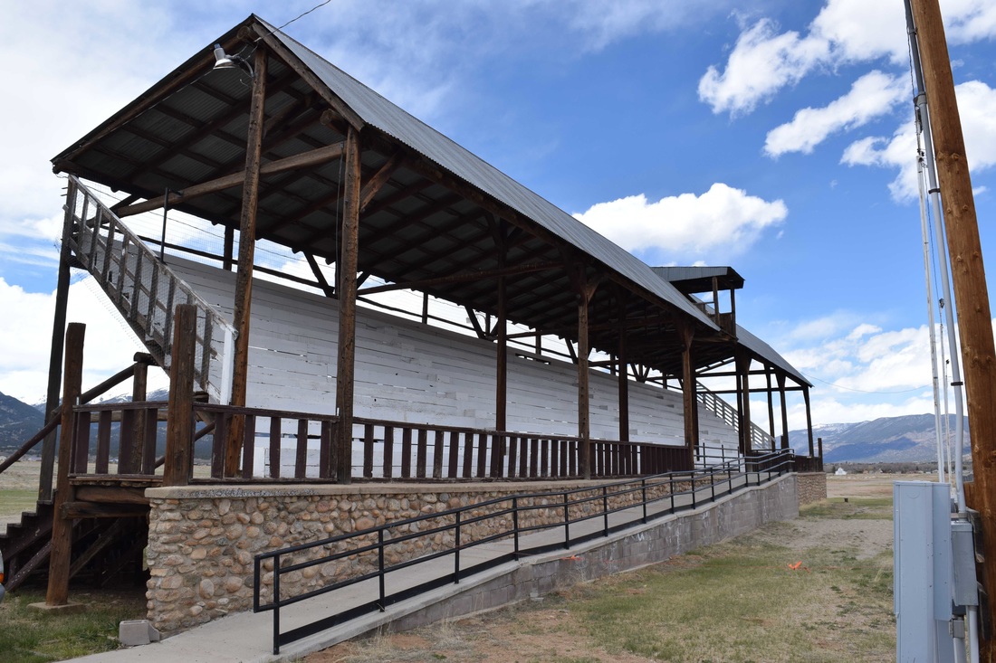
Head Lettuce Day/Collegiate Peaks Stampede Rodeo Grounds, Buena Vista, Colorado (2016)
The 1940 Head Lettuce Day/Collegiate Peaks Stampede Rodeo Grounds are locally significant in the area of Entertainment/Recreation for its association with the annual rodeo, an important Buena Vista and regional sporting and entertainment event and celebration recognizing the area’s ranching roots. The rodeo was and is a major community event that has included a parade and barbeque as well as the rodeo competition. Known as “the biggest weekend of the year in Buena Vista,” the rodeo boasts a western theme attracting people from throughout Chaffee County and surrounding areas. The grounds are also significant in the area of Social History as a project undertaken by the Work Projects Administration to provide work for the unemployed during the Great Depression. The construction engaged about two-dozen workers and injected money into the town economy. The resource is also architecturally significant as an example of an early twentieth-century small town rodeo grounds planned and constructed by the WPA and featuring a WPA Rustic grandstand, a half-mile racetrack, and corrals. WPA workers planned and laid out the grounds to replace an earlier venue and provide the community with a more substantial and well-planned rodeo facility. The project was sponsored by the Greater Arkansas River Nature Association with funding from the State Historical Fund..
The 1940 Head Lettuce Day/Collegiate Peaks Stampede Rodeo Grounds are locally significant in the area of Entertainment/Recreation for its association with the annual rodeo, an important Buena Vista and regional sporting and entertainment event and celebration recognizing the area’s ranching roots. The rodeo was and is a major community event that has included a parade and barbeque as well as the rodeo competition. Known as “the biggest weekend of the year in Buena Vista,” the rodeo boasts a western theme attracting people from throughout Chaffee County and surrounding areas. The grounds are also significant in the area of Social History as a project undertaken by the Work Projects Administration to provide work for the unemployed during the Great Depression. The construction engaged about two-dozen workers and injected money into the town economy. The resource is also architecturally significant as an example of an early twentieth-century small town rodeo grounds planned and constructed by the WPA and featuring a WPA Rustic grandstand, a half-mile racetrack, and corrals. WPA workers planned and laid out the grounds to replace an earlier venue and provide the community with a more substantial and well-planned rodeo facility. The project was sponsored by the Greater Arkansas River Nature Association with funding from the State Historical Fund..
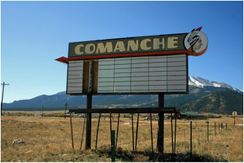
Comanche Drive-In, Buena Vista, Colorado (2014-15)
In 2015, the Comanche Drive-In Theater west of Buena Vista became the fifth drive-in to be listed in the National Register in the entire country. Experienced indoor movie theater operators John L. and Pearl Groy brought drive-in entertainment to the Buena Vista area in 1967, opening the facility after the peak in drive-in construction. It is Chaffee County’s only extant drive-in and the highest drive-in in elevation in the nation at 8,040’. The Comanche Drive-In represents the layout and components of a mid-twentieth century small-town drive-in theater, as reflected in the massive screen tower, rows of parking with speaker poles, attractions board/sign marquee, multipurpose projection building, ticket booth, and circulation system for entering and exiting. Drive-in theaters are a rapidly disappearing resource type: once numbering more than 4,000 venues throughout the country, there are now only 338 still open. Colorado once had more than sixty drive-ins; today, the Comanche Drive-In is one of just seven still operating. The Comanche is also notable for its continuing use of a reel-to-reel carbon arc lamp projection system—one of the few drive-ins in the nation still employing that technology that produces a brilliant white light. Buoyed by a strong local economy, the drive-in enjoyed its peak years in the early 1980s but continues to serve residents and visitors to the Buena Vista area. Prepared for the Greater Arkansas Nature Association with funding from the Colorado State Historical Fund.
In 2015, the Comanche Drive-In Theater west of Buena Vista became the fifth drive-in to be listed in the National Register in the entire country. Experienced indoor movie theater operators John L. and Pearl Groy brought drive-in entertainment to the Buena Vista area in 1967, opening the facility after the peak in drive-in construction. It is Chaffee County’s only extant drive-in and the highest drive-in in elevation in the nation at 8,040’. The Comanche Drive-In represents the layout and components of a mid-twentieth century small-town drive-in theater, as reflected in the massive screen tower, rows of parking with speaker poles, attractions board/sign marquee, multipurpose projection building, ticket booth, and circulation system for entering and exiting. Drive-in theaters are a rapidly disappearing resource type: once numbering more than 4,000 venues throughout the country, there are now only 338 still open. Colorado once had more than sixty drive-ins; today, the Comanche Drive-In is one of just seven still operating. The Comanche is also notable for its continuing use of a reel-to-reel carbon arc lamp projection system—one of the few drive-ins in the nation still employing that technology that produces a brilliant white light. Buoyed by a strong local economy, the drive-in enjoyed its peak years in the early 1980s but continues to serve residents and visitors to the Buena Vista area. Prepared for the Greater Arkansas Nature Association with funding from the Colorado State Historical Fund.
Commercial Hotel, Granite, Chaffee County, Colorado (2014-15)
The Commercial Hotel is believed first to have operated as a stage stop during the 1860s and 1870s on a stage road between Cañon City and Leadville traveled by the noted Barlow & Sanderson line. The oldest part of the building dates to ca. 1867-76. By about 1880-81 it evolved into the Commercial Hotel and played a vital role in the town’s commerce by providing lodging and meals for commercial travelers and tourists, a function essential for a thriving community. By offering overnight accommodations and hot food, the early hotels made trips to such isolated areas less difficult, allowing them to attract more potential residents as well as important business visitors. The building continued to function as a hotel through at least 1911. The hotel and the pre-1880 livery stable/blacksmith shop to the north are further significant as intact examples of Pioneer Log construction. Although Granite boomed in the early 1860s and for several years was the county seat of Lake County, there are only a small number of early log buildings remaining in the community. The hotel building is notable for displaying walls facing Main Street clad with board-and-batten siding, reflecting an attempt to transcend the rugged frontier environment, while less visible walls are mostly log construction with V and square notching. The Commercial Hotel and its companion livery stable are further significant as rare surviving examples of the town’s early commercial buildings. Fires in 1893, 1897, and 1939 destroyed most of Granite’s commercial district. Prepared for the Greater Arkansas Nature Association with funding from the Colorado State Historical Fund.
The Commercial Hotel is believed first to have operated as a stage stop during the 1860s and 1870s on a stage road between Cañon City and Leadville traveled by the noted Barlow & Sanderson line. The oldest part of the building dates to ca. 1867-76. By about 1880-81 it evolved into the Commercial Hotel and played a vital role in the town’s commerce by providing lodging and meals for commercial travelers and tourists, a function essential for a thriving community. By offering overnight accommodations and hot food, the early hotels made trips to such isolated areas less difficult, allowing them to attract more potential residents as well as important business visitors. The building continued to function as a hotel through at least 1911. The hotel and the pre-1880 livery stable/blacksmith shop to the north are further significant as intact examples of Pioneer Log construction. Although Granite boomed in the early 1860s and for several years was the county seat of Lake County, there are only a small number of early log buildings remaining in the community. The hotel building is notable for displaying walls facing Main Street clad with board-and-batten siding, reflecting an attempt to transcend the rugged frontier environment, while less visible walls are mostly log construction with V and square notching. The Commercial Hotel and its companion livery stable are further significant as rare surviving examples of the town’s early commercial buildings. Fires in 1893, 1897, and 1939 destroyed most of Granite’s commercial district. Prepared for the Greater Arkansas Nature Association with funding from the Colorado State Historical Fund.
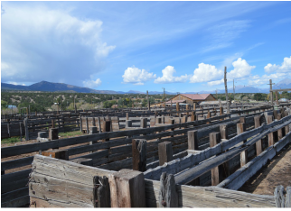
Salida Livestock Commission Company, Salida vicinity (2014-15)
The 1958 Salida Livestock Commission Company sale barn facility is significant for the role it played (and continues to play) in ranching and the marketing of livestock in central and southern Colorado. This facility served as one of the largest livestock sale barns in Colorado during the 1960s, with as many as 3,000 to 4,000 animals sold during a single sale. Today, the sale barn attracts buyers and sellers from Chaffee County, South Park, the San Luis Valley, and the Cañon City area, hosting weekly auctions in the fall and winter that drew large numbers of buyers and sellers to Salida and boosted the local economy. The sale barn complex is further significant as an intact example of a late 1950s livestock auction complex. The facility is organized to efficiently receive, care for, auction, and ship livestock, featuring loading and unloading docks; a large corral with alleys, loafing sheds, squeeze chutes, and pens of varying sizes to hold and move livestock; sales barn with scales, sales arena, office, and café; hay barn; and parking area. Especially important is the sales barn, which includes important original interior features such as the sales area with wood-paneled walls, a semi-circular show ring, steeply raked seating, and an auctioneer’s booth, and the original restaurant with knotty pine paneling on the walls and a 1950s semi-circular lunch counter with metal stools. Prepared for the Greater Arkansas Nature Association with funding from the Colorado State Historical Fund.
The 1958 Salida Livestock Commission Company sale barn facility is significant for the role it played (and continues to play) in ranching and the marketing of livestock in central and southern Colorado. This facility served as one of the largest livestock sale barns in Colorado during the 1960s, with as many as 3,000 to 4,000 animals sold during a single sale. Today, the sale barn attracts buyers and sellers from Chaffee County, South Park, the San Luis Valley, and the Cañon City area, hosting weekly auctions in the fall and winter that drew large numbers of buyers and sellers to Salida and boosted the local economy. The sale barn complex is further significant as an intact example of a late 1950s livestock auction complex. The facility is organized to efficiently receive, care for, auction, and ship livestock, featuring loading and unloading docks; a large corral with alleys, loafing sheds, squeeze chutes, and pens of varying sizes to hold and move livestock; sales barn with scales, sales arena, office, and café; hay barn; and parking area. Especially important is the sales barn, which includes important original interior features such as the sales area with wood-paneled walls, a semi-circular show ring, steeply raked seating, and an auctioneer’s booth, and the original restaurant with knotty pine paneling on the walls and a 1950s semi-circular lunch counter with metal stools. Prepared for the Greater Arkansas Nature Association with funding from the Colorado State Historical Fund.
Rock Ledge/Franzel Ranch, Buena Vista vicinity, Chaffee County, Colorado (2014-15)
The 120-acre Rock Ledge Ranch/Franzel Ranch west of Buena Vista possesses an important association with the history of agriculture in Chaffee County. Ernest and Belle Wilber homesteaded the property beginning in the late 1880s, constructing the first buildings and other improvements, raising field crops, vegetables, cattle, and eventually establishing a flourishing dairy. German immigrants Gustav and Marie Franzel acquired the ranch in 1908, completing other buildings, raising a family, and growing grains, vegetables, hay, and cattle on the land. The Franzels raised hogs and continued a sausage making tradition, producing such German favorites as liverwurst, blood sausage, and summer sausage. Descendants of the Franzels continue to own and operate the ranch. The ranch contains a variety of buildings representing late nineteenth and twentieth century ranch architecture, including a large log barn, machine shed, chicken house, brooder house, bunkhouse, blacksmith shop, ice house, and wood shed, as well as a historic cistern and a ditch. All designed in an unadorned, traditional, and functional vernacular manner, the buildings exhibit a variety of historic ranch construction materials, including logs, milled boards, wood shingles, corrugated metal, concrete, stone, and cinderblocks. Prepared for the Greater Arkansas Nature Association with funding from the Colorado State Historical Fund.
The 120-acre Rock Ledge Ranch/Franzel Ranch west of Buena Vista possesses an important association with the history of agriculture in Chaffee County. Ernest and Belle Wilber homesteaded the property beginning in the late 1880s, constructing the first buildings and other improvements, raising field crops, vegetables, cattle, and eventually establishing a flourishing dairy. German immigrants Gustav and Marie Franzel acquired the ranch in 1908, completing other buildings, raising a family, and growing grains, vegetables, hay, and cattle on the land. The Franzels raised hogs and continued a sausage making tradition, producing such German favorites as liverwurst, blood sausage, and summer sausage. Descendants of the Franzels continue to own and operate the ranch. The ranch contains a variety of buildings representing late nineteenth and twentieth century ranch architecture, including a large log barn, machine shed, chicken house, brooder house, bunkhouse, blacksmith shop, ice house, and wood shed, as well as a historic cistern and a ditch. All designed in an unadorned, traditional, and functional vernacular manner, the buildings exhibit a variety of historic ranch construction materials, including logs, milled boards, wood shingles, corrugated metal, concrete, stone, and cinderblocks. Prepared for the Greater Arkansas Nature Association with funding from the Colorado State Historical Fund.
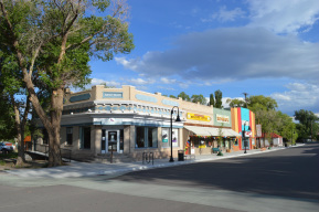
Downtown Saguache Historic District, Saguache County, Colorado (2013-14). The 7.7-acre, 49-resource Saguache Downtown Historic District is locally significant under National Register Criterion A in the area of Commerce for its historic role as the commercial center of the Town of Saguache and the upper San Luis Valley since its founding in 1874. The district is further locally significant under National Register Criterion C in the area of Architecture, representing an intact collection of one- and two-story late nineteenth- and early twentieth century commercial buildings, including an impressive number of buildings featuring false front and adobe construction. The period of significance extends from 1874 through 1964, in keeping with National Register guidelines. A Certified Local Government grant to the Town of Saguache funded the project.
Hotel Holly/Haswell Hotel, Haswell, Colorado (2013)
The 1907 Hotel Holly/Haswell Hotel was the earliest public accommodation in Haswell, serving the area’s residents, including teachers and work crews, as well as members of the traveling public. As one of the largest buildings in the community and with a popular dining room, the hotel became a gathering place for local social gatherings and other events. In addition to the hotel, the 0.4-acre complex includes an office/filling station, bunkhouse, chicken coop, and garage. Front Range undertook the project for the Kiowa County Historic Preservation Commission under funding from a Certified Local Government grant.
The 1907 Hotel Holly/Haswell Hotel was the earliest public accommodation in Haswell, serving the area’s residents, including teachers and work crews, as well as members of the traveling public. As one of the largest buildings in the community and with a popular dining room, the hotel became a gathering place for local social gatherings and other events. In addition to the hotel, the 0.4-acre complex includes an office/filling station, bunkhouse, chicken coop, and garage. Front Range undertook the project for the Kiowa County Historic Preservation Commission under funding from a Certified Local Government grant.
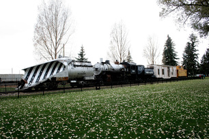
Snow Train Rolling Stock, Laramie, Wyoming, National Register District Nomination (2012-13). Front Range prepared a National Register district nomination for the Snow Train, Rolling Stock located in Railroad Heritage Park, Laramie, Wyoming. The resources comprised the first railroad rolling stock to be listed within Wyoming. The train consists of a wedge snow plow, steam locomotive, tender, bunk car, and caboose. The project was conducted for the Albany County Historic Preservation Board and the Laramie Railroad Depot Association and funded by a Certified Local Government grant.
|
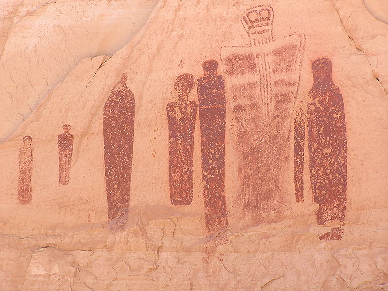
Horseshoe Canyon National Register of Historic Places Nomination, Canyonlands National Park, Utah (2011)
Front Range worked with RMC Consultants to produce an expanded and updated National Register district nomination for an area of Canyonlands National Park containing some of the most significant rock art in North America, including the Great Gallery. |
|
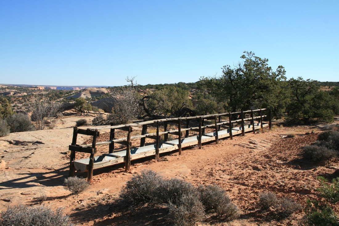
Cabin Springs and Neck Springs Grazing District, National Register Historic District Nomination, Canyonlands National Park, Moab, Utah vicinity (2009-10)
Front Range prepared a National Register historic district nomination for an area in the northern area of the park that contains resources related to grazing and water development in the 1930s, including two livestock troughs erected by the Civilian Conservation Corps (CCC). Front Range performed the work for the National Park Service as a subconsultant to RMC Consultants. |
|
Trout Creek/Annex/Settele Ranch, Fairplay vicinity, Colorado (2007)
The district nomination included more than two dozen buildings and 2,100 acres in the Trout Creek valley southeast of Fairplay. The ranch, which produced large amounts of hay, was associated with several prominent cattle and sheep ranchers, including Edward P. Arthur, Charles H. Wadley, and James L. Settele. |
|
Monument Valley Park, Colorado Springs, Colorado (2006)
This narrow 147-acre urban park was established by William Jackson Palmer in 1907 and further developed by WPA public works projects in the 1930s. A number of Rustic style features are present in the park. |
|
Hutchinson Ranch (Boundary Expansion and Update), Salida, Colorado (2004-2005)
A revised and expanded nomination, including new documentation, for a historic cattle ranch in Chaffee County established by Joseph S. and Annabel Hutchinson in the 1870s. |
|
Trujillo Homestead, Alamosa County, Colorado (2004)
The historic homestead of a first-generation Hispanic-American cattle rancher Pedro Trujillo. The site is also associated with the violent disputes between Anglo cattlemen and Hispanic sheepraisers during the early twentieth century. |
|
Medano Ranch Headquarters, Alamosa County, Colorado (2004)
The headquarters area of a pioneer San Luis Valley cattle ranching empire. |
|
Crested Butte, Colorado, Revised Nomination (2001-2002)
Revised boundaries, an expanded historic context, architectural descriptions, and new photographs and maps for more than 300 buildings in the historic mining town of Crested Butte, Colorado. |
|
Colorado Salt Works, Hartsel vicinity, Park County, Colorado (2000-2001)
One of the state's earliest industries and the only salt production facility of its kind built in Colorado. This rare resource type is an 1860s plant that used kettle and pan technology to produce salt for the fledging mining frontier. |
|
Salt Works Ranch, Hartsel vicinity, Colorado (2000-2001)
The headquarters area of an agricultural enterprise encompassing 128 acres, including an original 1862 homestead cabin and a Second Empire style main house, as well as a variety of agricultural buildings. |
|
Wahl Ranch, Jefferson vicinity, Park County, Colorado (2000)
A large historic ranch complex at the base of Kenosha Pass, with buildings dating from 1883 through 1948. |
|
Mammoth Hot Springs, Yellowstone National Park, Wyoming (1999-2000)
Prepared for the National Park Service through the National Trust for Historic Preservation, this district embraces the historic concessions area of the national park. |
|
Stocke-Walter Historic District, Arvada, Colorado (1999)
A historic residential neighborhood lying east of Arvada’s historic commercial area. |
|
Buckley Ranch, Hartsel vicinity, Park County, Colorado (1999). James B. Putnam homesteaded the ranch’s original 160 acres in 1881. When purchased by the Buckley family in 1908, the cattle ranch spread across more than 2,500 acres. During the 1920s, sheep replaced cattle as the primary focus of ranching in the South Park area, and the production of hay also played an important role in the successful operation of the ranch.
|
Reno Park Historic District, Arvada, Colorado (1999). A historic residential neighborhood lying west of Arvada’s historic commercial area.
West Side Neighborhood Residential District Expansion. Denver, Colorado(1999)
A National Register nomination substantially expanding the existing West Side NRHP Historic District in the La Alma-Lincoln Park neighborhood was produced for NEWSED, a nonprofit community development organization. Due to neighborhood opposition, this nomination was not submitted to the State Review Board.
A National Register nomination substantially expanding the existing West Side NRHP Historic District in the La Alma-Lincoln Park neighborhood was produced for NEWSED, a nonprofit community development organization. Due to neighborhood opposition, this nomination was not submitted to the State Review Board.
|
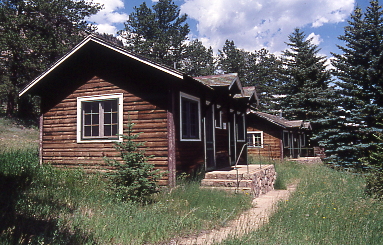
McGraw Ranch, Estes Park, Colorado (1998) A historic cattle and dude ranch now within the boundaries of Rocky Mountain National Park. Prepared for the National Park Service.
|
|
Arvada Downtown, Arvada, Colorado (1998)
A district with 67 resources embracing Arvada’s historic commercial area and including commercial buildings, churches, a grange hall, a school, and a few residences. |
|
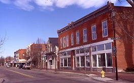
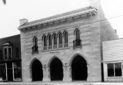
Littleton Downtown, Littleton, Colorado (1997) The two-and-a-half block commercial heart of historic Littleton, encompassing 33 buildings, including the J.J.B. Benedict-designed Town Hall.
|
|
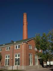
Denver Medical Depot, Denver, Colorado (1997)
A 37-acre World War II medical supply facility in northeast Denver designed by architect Temple H. Buell. The red brick building complex later housed the Air Force Accounting and Finance Center. |
|
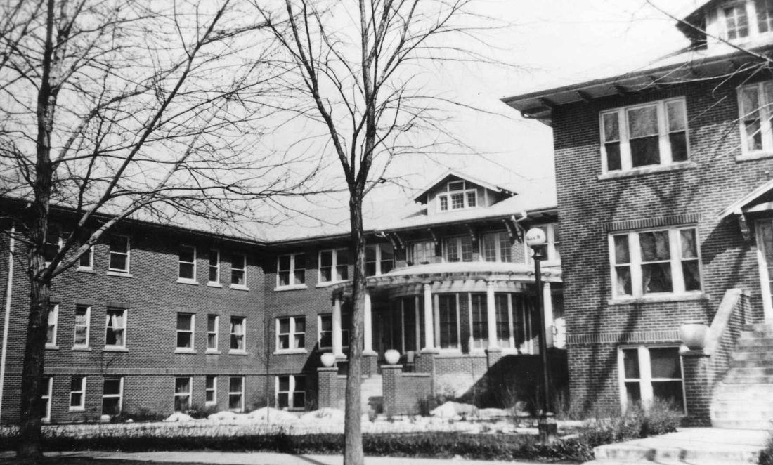
Tilden School for Teaching Health, Denver, Colorado (1995)
The campus of a 1915-32 multi-building sanitarium associated with Dr. John H. Tilden and principally designed by Denver architect Harry W.H. Edbrooke. |
|
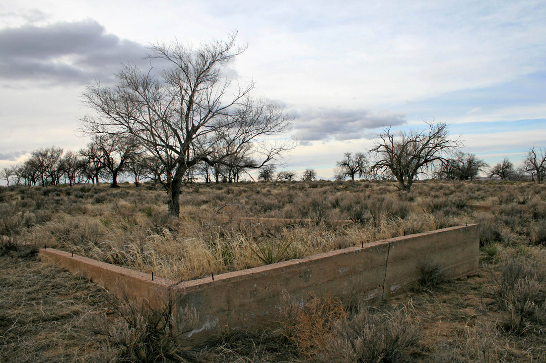
Granada Relocation Center (Camp Amache), Prowers County, Colorado(1993-94)
The site of a World War II era Japanese American relocation center in Prowers County of southeastern Colorado. The project also included videotaping interviews with former residents of the camp and producing cost estimates for improving access and interpretation of the site. The project was sponsored by the Denver Central Optimist Club and the Town of Granada. The nomination was later used to prepare a National Historic Landmark nomination for the site. |
|
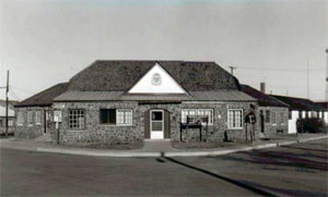
Camp George West, Golden, Colorado (1992) A Colorado National Guard headquarters facility that features a variety of Rustic stone buildings.
|
|
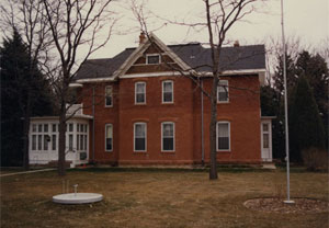
Milne Farm, Weld County, Colorado (1992) A Centennial Farm just west of Lucerne, Colorado, including the main farmhouse, barn, and associated agricultural buildings. James Grant Milne, a Scottish emigrant, constructed the Edwardian Vernacular-style brick farmhouse in 1892.
|
|
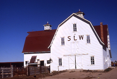
SLW Ranch, Weld County, Colorado (1991) A historic horse and cattle ranch established by a Scottish capitalist in the early 1880s. Resources include the main ranch house, a large barn, and a variety of outbuildings.
|
|
Elmer and Etta Ball Ranch, Weld County, Colorado (1991). A family ranch established in 1914 where the Balls raised cattle and pinto beans. The headquarters area includes the main ranch house, a barn, and other outbuildings.
|
|
Rim Rock Drive, Mesa County, Colorado (1990-92)
A 22.4 mile roadway constructed within Colorado National Monument near Grand Junction, Colorado. The road was a Great Depression-era public works project completed with CCC and WPA labor. The National Park Service engaged Front Range to develop a historic context, perform a field survey with photographic documentation, develop registration requirements, and prepare the nomination. |
|
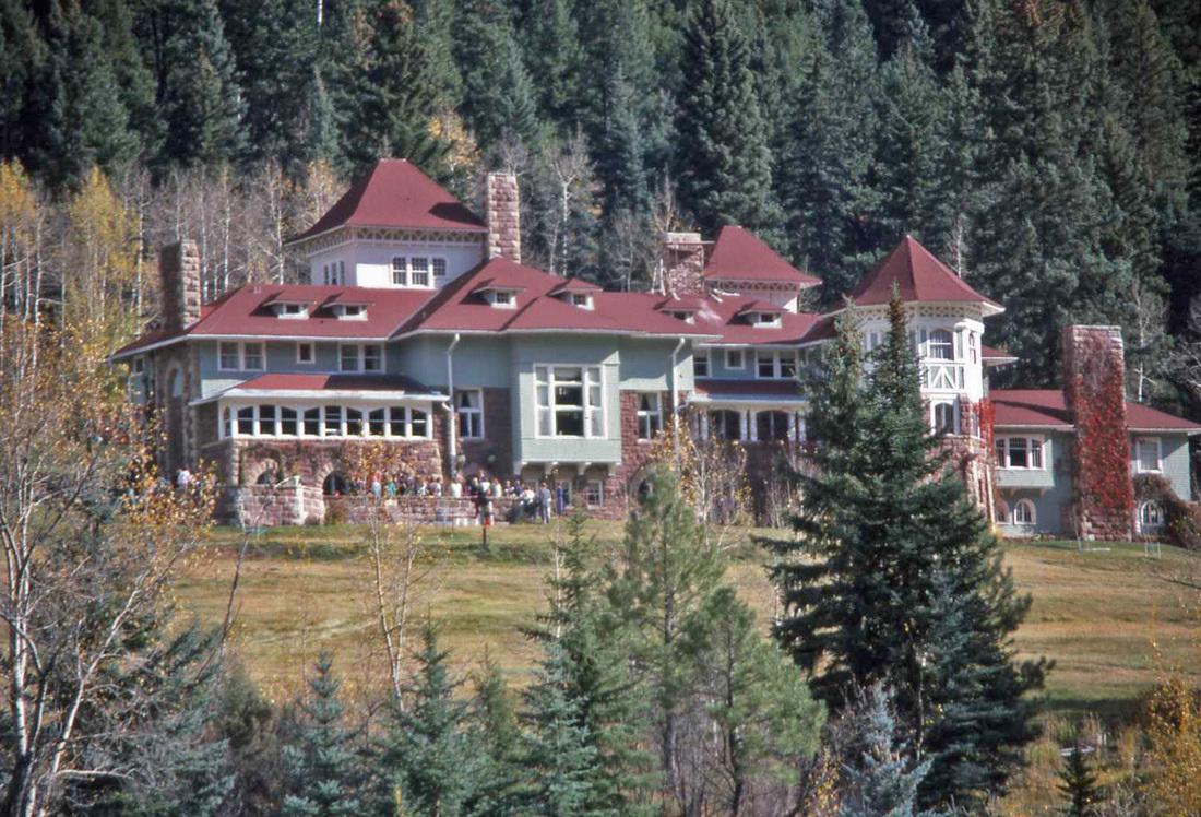
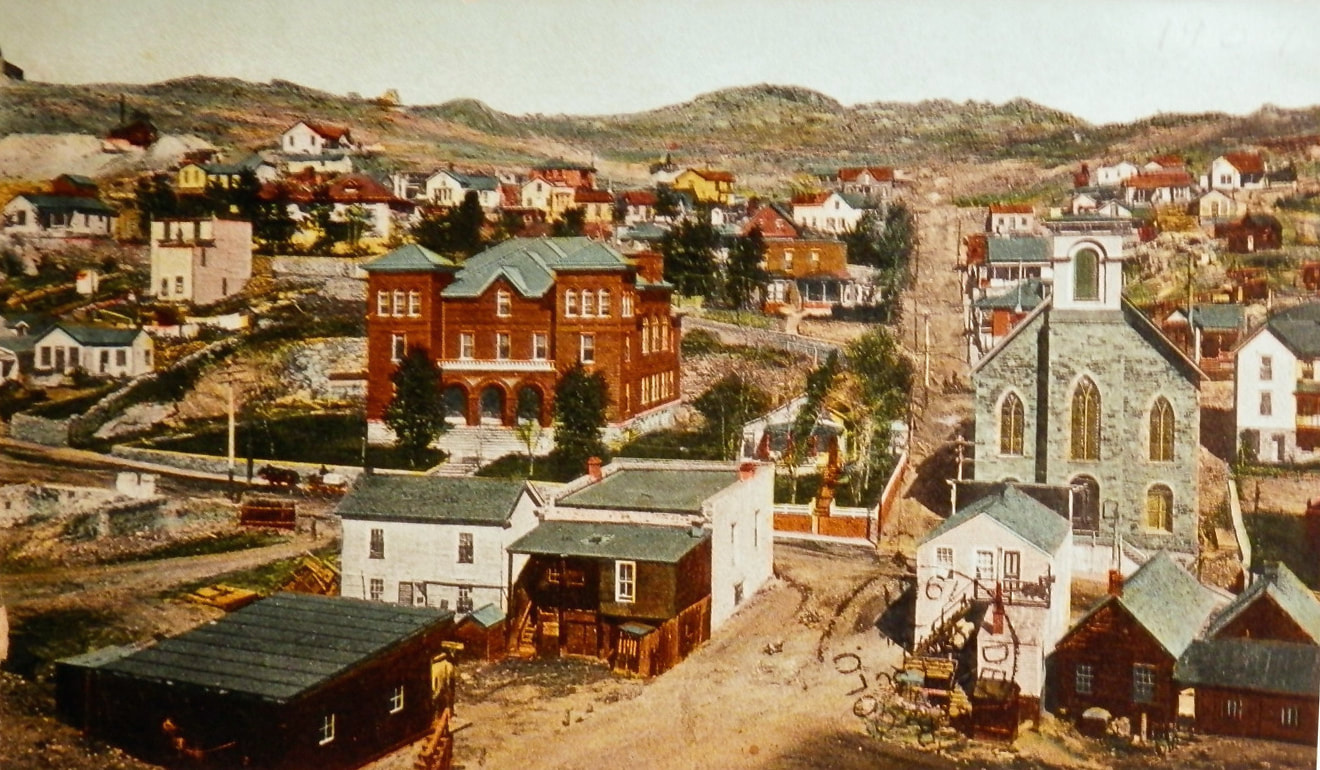
Redstone Historic District, Pitkin County, Colorado (1989)
A Colorado Fuel & Iron Company town associated with John C. Osgood and coal mining in Pitkin County. Architect Theodore C. Boal of New York designed many of the district’s buildings. The district includes Osgood's "Cleveholm" (at left). |
|
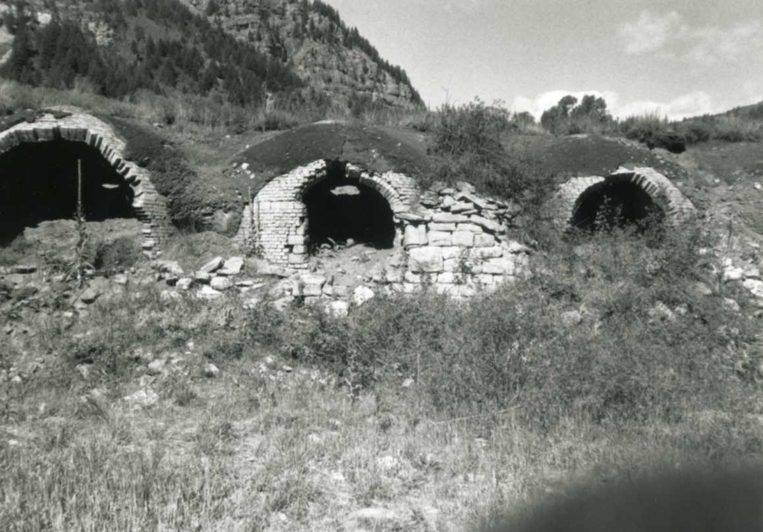
Redstone Coke Oven Historic District, Pitkin County, Colorado (1990)
A complex of Colorado Fuel & Iron Company beehive coke ovens associated with Redstone, Colorado. |
|
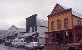
Black Hawk and Central City, Gilpin County, Colorado (1989)
Front Range assisted the National Park Service in correcting and revising maps prepared for a National Register nomination of the Central City/Black Hawk historic district. |
|
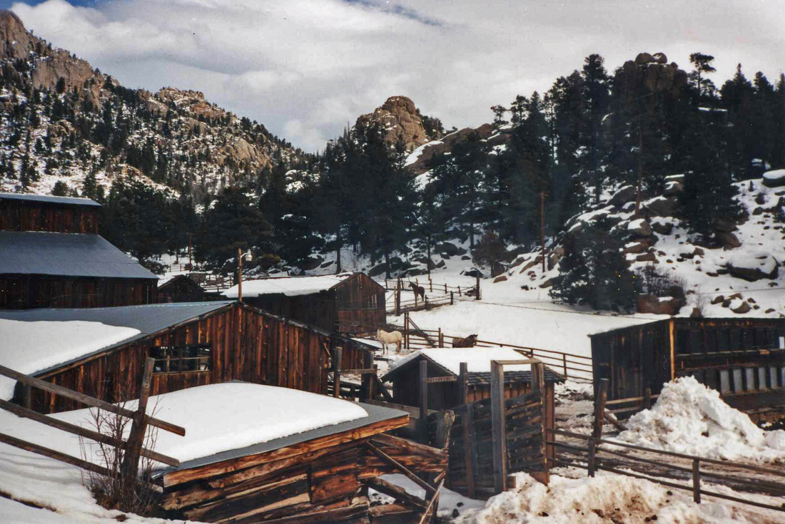
MacGregor Ranch, Estes Park, Colorado (1989) A historic cattle and dude ranch in Rocky Mountain National Park.
|
|
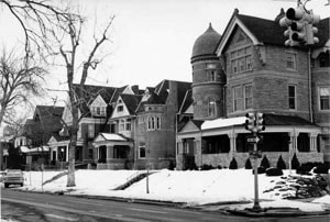
Swallow Hill National Register Nomination, Denver, Colorado (1987)
One of Denver’s most significant collections of late nineteenth and early twentieth century Queen Anne-style residences. Located in northeast Denver. |
